-1

I have used openlayers plugin, and I downloaded openstreetmap. I need now only a part of the map, not all of it, how can I do that?

I need to crop Dubai city as example, I tried to use Clip in Vector menu, but I couldn't understand what did it mean by Input vector layer and clip layer since the software selected the same file already!

MRAN
  • 93
  • 1
  • 2
  • 10
  • How is this question different from your previous http://gis.stackexchange.com/questions/85737/how-to-crop-google-hybrid-map-in-qgis? The Openlayers plugin only provides access to raster data which can not be used by the vector clip tool. Please be more clear about what you are trying to achieve? Do you want to extract vector data or raster data? – underdark Feb 08 '14 at 20:45
  • Sorry for the inconvenience, but all what I need is interactive imagery map for a city only and that is not succeeded with vector clip! I need the pretty image of the openstreet map like the one in their website, but when i download them, I found a plain view with lines and points only those I don't need at the first place! – MRAN Feb 09 '14 at 02:49
  • If you say "interactive" map: Do you mean interactive in QGIS? Or do you want to create a web map? Sorry to insist, but it's still not totally clear to me what you are trying to achieve. – underdark Feb 09 '14 at 12:12
  • @MRAN Did you find any way to do this? – mapsir Feb 10 '14 at 12:43
  • has my answer not addressed this? – Ger Feb 12 '14 at 11:07

2 Answers2

0

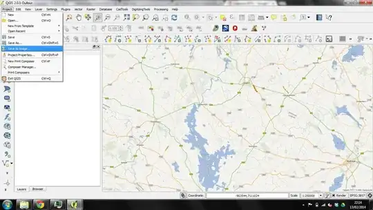
The best way to do it is to save project as a an image. this will save the background mapping as a single georeferenced raster image.

enter image description here

There is no specific way to crop an open map but this is the best way i have found to do it.

Let me know if i need to expand.

Expansion based on comments below.

What you seem to want to do is to maintain the different display modes of the open maps automatically for ilustration in the viewer and not in print format.

Therefore repeat the process for each level of zoom you wish and add the created raster image to the file. (as shown above....ie project save as image. only before you save select the zoom you want eg 1:250000, then to 1:100000 then 1:50000 etc etc etc.)

In the layer properties box select the tab General. On this there is a tickable box for scale dependant visabilities.

enter image description here

Choose your zoom scale in between which the layer will be visible. So as you zoom in each layer will turn on and off at set points of zoom. You will need to play around with it to meet your needs. in my example after i add the first saved image will be displayed from like 1 billion to 1:150000, as i said what suits YOUR project).

Lastly, no, as far as i am aware you cant set it that they cant zoom out. but the image will only e there between the zoom levels and it will only be the square you saved. but they can always edit it themselves in their project if it is giving it to someone else.

Ger
  • 2,575
  • 8
  • 35
  • 45
  • I did that, but I lost zoom in/zoom out advantage! all what I need is a certain city map with imagery look, and the I can add a vector grid on it. – MRAN Feb 09 '14 at 02:50
  • You will need to save several layers and load them at the different scale....what you are talking about is impossible but just save several layers and set scale dependant visabilities. – Ger Feb 09 '14 at 12:07
  • What did you mean by "set scale dependant visabilities" ? How can I do that? thanks – MRAN Feb 09 '14 at 17:49
  • See expanded answer above. As you zoom in and out you can set the layers to turn on and off. For eg on the OS webviewer 1:250K mapping is displayed first, then 1-50K then streetview. – Ger Feb 10 '14 at 09:41
  • Sorry, First point: you said that "add the created raster image to the file." in QGIS, do you mean "Save as image" option? since there is no way to save the view but as image! – MRAN Feb 12 '14 at 11:21
  • Second point: What is the different between (General>Scale dependent visibility) and (Labels>Rendering>Scale based visibility)? – MRAN Feb 12 '14 at 11:37
  • Third point: If there's any way to save the project to start from a certain scale, such as 1:10000 and the user only can zoom in, this might help.. – MRAN Feb 12 '14 at 11:39
  • seee above.....again....really think we may be missing something here....like a book. – Ger Feb 13 '14 at 22:19
  • :) .. Sorry for the inconvenience, and thank you very much. – MRAN Feb 14 '14 at 07:59
-1

Install JOSM from JOSM download

and cut your area with a selectable frame then export it.

Balazs
  • 51
  • 4
  • I did install JOSM, and loaded the desired map, how can I cut the area? I didn't find any cut or crop tools! – MRAN Feb 09 '14 at 04:17