4

I'm working on a project where it matters greatly whether or not a piece of land is on a private road.

Google Maps in many cases takes private roads (for example in master-planned subdivisions) and treats them in the same way it does for public roads.

Is there any quick way to check whether a road is privately owned or public?

In a lot of cases, even if a road is public it can be privately owned.

PolyGeo
  • 65,136
  • 29
  • 109
  • 338
boulder_ruby
  • 1,824
  • 4
  • 27
  • 43
  • 2
    I'm confused by "owned". Could you elaborate? In my previous job at a city government we had a large amount of "public roads" that were "privately maintained". Anybody could drive on them, but the maintenance was the responsibility of the HOA or developer. – Craig Oct 01 '13 at 13:31
  • 5
    I would strongly recommend that you do NOT try to use Google for any indication of legal ownership. – MappaGnosis Oct 01 '13 at 13:38
  • It might also matter where in the world you are at. Consider adding that information to your question. – Martin Oct 01 '13 at 13:42
  • @Martin: Good point. Typical American. I'm in the US. – boulder_ruby Oct 03 '13 at 14:54
  • @Craig: I think its last thing you were talking about. A privately owned road owned by a development that is publicly accessible and legal to do so – boulder_ruby Oct 03 '13 at 14:56
  • 1
    Our county has a number of subdivisions that have popped up in the last decade that have decided not to dedicate the roads as public. Therefore keeping them as part of the common area maintained by the HOA. None of the mass consumption website or services reflect that information. Even the Census Bureau stripped that off our centerline files when we used to give it to them. You will most likely have to go through the county assessors or recorder of deeds offices (or local equivalent) for your project areas to get that kind of information. – Lemur Oct 03 '13 at 15:34

1 Answers1

3

To answer this another question ("How to identify front of land lot?"), we need also to separate "property boundary" of land lot from public boundary of lanes, sidewalks and other public parcels of a city block.

There are another concept, between "privately owned" and "public" (not privately owned): the condominium, where the lanes, sidewalks, gardens, etc. are a commonhold of many land lot owners, tipically at the same city block. Some areas of some city blocks have condominium characteristics, because are shared areas.

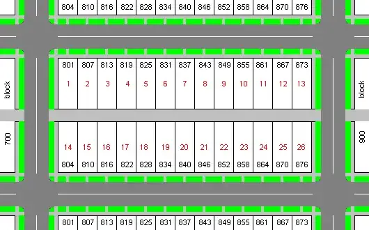
The city block illustration bellow show a case: a lane (light gray) in the block, that is not a "public" street (dark gray), but an access medium (like an alley) for land lot owners.

city block illustration

Translating this concepts to GIS:

  • There are many layers with this information: streets, lots (land-lots), blocks (city blocks), and others.

  • Some cadastral data have this information: the main source for Google Maps is the OpenStreetMap where (check its Wiki), many cadastral information (as low/high traffic) is provided. Many oficial data (from city municipalities) have list of names of public streets.


So, "how do I determine if a road is privately owned or not?", and not only at USA:

  1. Use all informations. Start with the "oficial" or the "consensual" ones. Example: big (high traffic) roads, big streets, etc. that are always public, and oficial data (law) that express what are public.

  2. Use parcels (blocks and lots) as reference about "inside/internal street": all that is internal of parcel polygon and is not at item-1, is suspected to be not public.
    Example: a very low traffic alley, with no name, short length (block length), is a good candidate to non-public. An alley internal to a non-public land lot, in general (check USA/state/city rules), is a non-public street.
    Important: all the "streets" contained into parcels officially declared as "closed horizontal condominium", are non-public.

  3. (if you did it all yourself) Show and talk about with your pairs: refine and check information again, when your work is questioned.

Peter Krauss
  • 2,292
  • 23
  • 43