Recently I have worked with some raster dataset. And I found there are different kind of raster dataset. Till now I have worked with grid type raster dataset and my add-in works fine with this type. But recently I tried to work with a tiff type raster dataset and the tool didn't work properly. I couldn't find any problem with my code and after converting that tiff data to grid format also worked fine. So, I think data is valid and also my code is okay too.
Here is my question now: is there any difference between different type of raster from a programmer perspective? There I found another question like mine. But that answer is not from programmer's perspective and also an old thread.
I am using arcgis 10.0. I use arcpy and arcobjects.net both in my add-in.
EDIT: After investigating a lot, I found some strange things. To describe those, need to describe the process.
Process Description:
- I exported a raster in tiff format.
- Copy that raster to a different folder.
- I did
Fill (Spatial Analyst)through arccpy on copy tiff raster.
the Fill (Spatial Analyst) tool gives a wrong output for copy tiff raster. And of course from my arcpy code also. And that was the reason behind posting this question. But suddenly I noticed that, the exported tiff raster gives correct output for Fill (Spatial Analyst) tool.
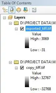
The value of the copy tiff raster is same as exported tiff raster but the range of highest value and lowest value is changed. And most important thing is, when I clipped from copy tiff raster, then the clipped raster also gave correct answer.
What can be the problem with this raster? Why does it behave this way? Does this problem can occur any time?