I am presently using LAStools to analyse LiDAR data. Can LAStools classify the points into various features such as vegetation, roads, buildings etc? If so, how is it done?
Asked
Active
Viewed 1.0k times
3 Answers
10
LASTools can perform a ground classification using "lasground" and then can perform some limited feature classification using "lasclassify". The performance and quality of feature classification in point clouds is strongly influenced by the type of landscape collected. Some landscapes just do not lend themselves to acceptable automated results. The best feature classification is provided when the vendor performs a "hands on" approach where considerable editing is performed after a given ground/feature classification algorithm is applied.
I am not sure how many tools are implemented in the ArcGIS LAS Toolbox. You may want to look at the available LAS commandline executable tools for more detailed analysis.
If your data was collected in an area with forest canopy or topographic relief I would recommend using the MCC algorithm for ground classification. This method uses a Thin Plate Spline and produces very good results. I am not overly fond of TIN based methods because of the surface bias, distortion and noise that they tend to produce.
Jeffrey Evans
- 31,750
- 2
- 47
- 94
-
Does LASTools require an intensity value or does it classify points based on height above ground? – jtgis Nov 12 '13 at 22:18
-
1No need for intensity. It tends to not be calibrated so is not often used in formalized procedures. Unfortunately, LASTools just went commercial. As an "free" alternative check out BCAL Lidar Tools (http://bcal.boisestate.edu/tools/lidar/). It requires the IDL Virtual Machine and has a nice set of tools written in IDL. – Jeffrey Evans Nov 13 '13 at 18:52
-
@JeffreyEvans thanks for posting this exceptional resource - classification of ground versus non-ground in a particularly dense conifer forest was spot on using MCC – AlecZ May 01 '20 at 20:46
3
About the lasclassify tool, be aware the .las files need
to already have ground points classified and point heights computed*.
See examples from lasclassify README:
lasground -i lidar.las -o lidar_with_bare_earth.las -city
lasheight -i lidar_with_bare_earth.las -o lidar_with_heights.las
lasclassify -i lidar_with_heights.las -o lidar_classified.las
Finds the ground points with lasground, computes the height of each point with lasheight, and classifies buildings and high vegetation with the default settings.
*To 'compute point heights' is also known as 'normalizing'. For example, see: Normalizing point cloud data.
Alternatively, one might find useful the Google Groups: LAStools - efficient tools for LiDAR processing, which is led by LAStools' developer Martin Isenburg.
Andre Silva
- 10,259
- 12
- 54
- 106
2
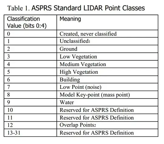
I'm not familiar with lastools, typically a las dataset has a class column that classifies the various points, see image below:
If you cannot process in lastools, then you can definitely do this in GRASS or ArcGIS using GeoCue utility.
artwork21
- 35,114
- 8
- 66
- 134
-
2This is only the case if the vendor processed the data to add this LAS classification field. This is not always standard practice and is reflected in the contract that the data was collected under. – Jeffrey Evans Jan 25 '13 at 19:32