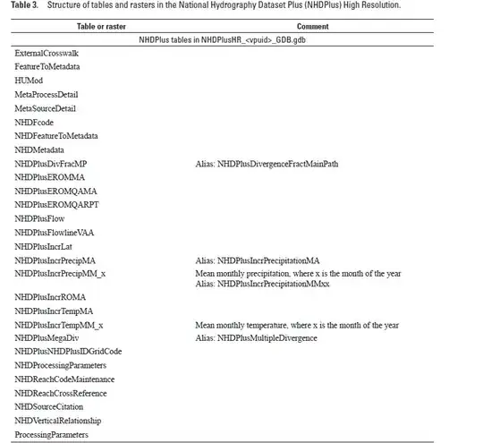
I am trying to work with the NHDPlus High Resolution dataset from the USGS. Looking at the documentation, there should be all sorts of data table available as well as mapping layers but the only thing I can access from the GDB file are the following layers:
Input:
import fiona
fiona.listlayers(r'.\NHDPlus_H_National_Release_1_GDB.zip')
Output:
['NHDPlusConnect',
'NHDPlusGageSmooth',
'WBDHU12',
'NonNetworkNHDFlowline',
'NetworkNHDFlowline',
'NHDWaterbody',
'NHDPoint',
'NHDPlusWall',
'NHDPlusSink',
'NHDPlusGage',
'NHDPlusCatchment',
'NHDPlusBoundaryUnit',
'NHDLine',
'NHDArea',
'NHDPlusFlow']
How can I access the data tables that are also in this file?
Edit: I expect to see the following features and table as described in pages 5 and 6 of the user documentation previously referenced:
 [
[
https://prd-tnm.s3.amazonaws.com/StagedProducts/Hydrography/NHDPlusHR/Beta/GDB/NHDPLUS_H_0101_HU4_GDB.zipand find 85 layers with fiona.listlayers – BERA May 24 '23 at 18:06