Have a go taking this code and modifying it to suit
This takes a full sized grid extent, and produces a subset of vector grid tiles with a level, row and column id for the full grid where the tiles intersect an area of relevance
I'm going to use this vector in FME for cutting out tiles from a larger raster layer for Spectrum Spatial, but if you were to do this in QGIS perhaps you could pair this with some sort of looping that runs through every tile and uses Clip raster by extent or Clip raster by mask layer
You could use a definition query (Extract by expression) for the looping perhaps, as well as to only render out a specific level
import time
startTime = time.time()
#Variable setting
minimumXFullExtent = -40867.905
maximumXFullExtent = 3329926.909
maximumYFullExtent = 8483438.288
minimumYFullExtent = 5112643.474
widthAndHeightOfSquareExtent = 3370794.814
theSpacing = widthAndHeightOfSquareExtent
coordSys = 'EPSG:7855'
extent = str(minimumXFullExtent) + ',' + str(maximumXFullExtent) + ',' + str(minimumYFullExtent) + ',' + str(maximumYFullExtent) + ' [' + coordSys + ']'
directory = 'D:/BasemapTiling/Bounds/'
name = 'BasemapTilingV1'
smallerAreaForTiling = 'D:/Whatever/YourRelevantArea.gpkg'
listOfLevels = []
#Start at the highest tiling level and work your way down
for x in range(1,17):
    print(x)
#Halve the tile dimensions each time
theSpacing = theSpacing/2

#Make a grid based on the original extent or on the extent of the latest subset
processing.run("native:creategrid", {'TYPE':2,'EXTENT':extent,
'HSPACING':str(theSpacing),'VSPACING':str(theSpacing),'HOVERLAY':0,'VOVERLAY':0,'CRS':QgsCoordinateReferenceSystem(coordSys),'OUTPUT':directory + name + 'Level' + str(x) + '.gpkg'})

#Remove fields to save space
processing.run("qgis:deletecolumn", {'INPUT':directory + name + 'Level' + str(x) + '.gpkg','COLUMN':['id','left','top','right','bottom'],
'OUTPUT':directory + name + 'Level' + str(x) + 'Reduce.gpkg'})

#Extract only the tiles relevant to the subset
processing.run("native:extractbylocation", {'INPUT':directory + name + 'Level' + str(x) + 'Reduce.gpkg','PREDICATE':[0,1,4,5,6],
'INTERSECT':smallerAreaForTiling,'OUTPUT':directory + name + 'Level' + str(x) + 'ReduceExtract.gpkg'})

#Calculate the column number
processing.run("native:fieldcalculator", {'INPUT':directory + name + 'Level' + str(x) + 'ReduceExtract.gpkg','FIELD_NAME':'Column','FIELD_TYPE':1,'FIELD_LENGTH':0,'FIELD_PRECISION':0,
'FORMULA':'round (\r\n ( x ( centroid ( $geometry ) ) - (' + str(minimumXFullExtent) + '+ 1))\r\n / (\r\n range ( x ( centroid ( $geometry ) ) ) \r\n / (\r\n count_distinct ( x ( centroid ( $geometry ) ) )\r\n -1\r\n )\r\n )\r\n)\r\n',
'OUTPUT':directory + name + 'Level' + str(x) + 'ReduceExtractWColumn.gpkg'})

#Calculate the row number
processing.run("native:fieldcalculator", {'INPUT':directory + name + 'Level' + str(x) + 'ReduceExtractWColumn.gpkg','FIELD_NAME':'Row','FIELD_TYPE':1,'FIELD_LENGTH':0,'FIELD_PRECISION':0,
'FORMULA':'round (\r\n ( ' + str(maximumYFullExtent) + '- 1 \r\n - \r\n y ( centroid ( $geometry ) ) \r\n  ) / \r\n ( range ( y ( centroid ( $geometry ) ) ) \r\n  / \r\n ( count_distinct ( \r\n ( y ( centroid ( $geometry ) ) ) , x ( centroid ( $geometry ) ) \r\n ) -1 )\r\n )\r\n)\r\n',
'OUTPUT':directory + name + 'Level' + str(x) + 'ReduceExtractWColumnWRow.gpkg'})

#Add the level
processing.run("native:fieldcalculator", {'INPUT':directory + name + 'Level' + str(x) + 'ReduceExtractWColumnWRow.gpkg','FIELD_NAME':'Level','FIELD_TYPE':1,'FIELD_LENGTH':0,'FIELD_PRECISION':0,
'FORMULA':str(x),'OUTPUT':directory + name + 'Level' + str(x) + 'ReduceExtractWColumnWRowWLevel.gpkg'})

#Add to the list of what has been made so far
listOfLevels.append(directory + name + 'Level' + str(x) + 'ReduceExtractWColumnWRowWLevel.gpkg')

#Get the extent of the latest grid extract to make the next grid
extentVector = QgsVectorLayer(directory + name + 'Level' + str(x) + 'ReduceExtract.gpkg')
extentRectangle = extentVector.extent()
xminExtentRectangle = extentRectangle.xMinimum()
xmaxExtentRectangle = extentRectangle.xMaximum()
yminExtentRectangle = extentRectangle.yMinimum()
ymaxExtentRectangle = extentRectangle.yMaximum()
coordsExtentRectangle = "%f,%f,%f,%f" %(xminExtentRectangle, xmaxExtentRectangle, yminExtentRectangle, ymaxExtentRectangle)
extent = coordsExtentRectangle + ' [' + coordSys + ']'

#Prevent this from running for ages if you're just testing
currentTime = time.time()
timeSoFar = currentTime - startTime
if timeSoFar > 20000:
    break


#Bring it all together
processing.run("native:mergevectorlayers", {'LAYERS':listOfLevels,
'CRS':QgsCoordinateReferenceSystem(coordSys),'OUTPUT':directory + 'MergedLevels' + name + '.gpkg'})
For this I used some modified code from Vector grid id generation
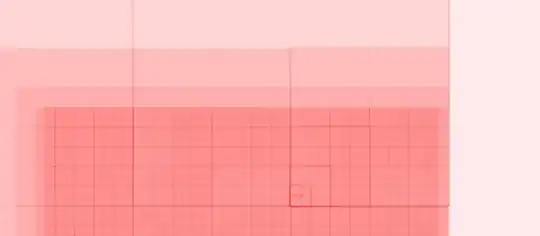
This is a visualisation of the levels of the grid and their attributes