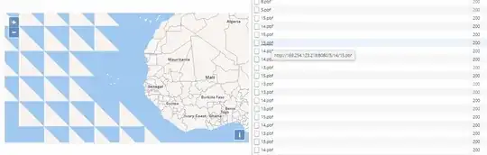
Using the information in this question, I managed to unpack a random small mbtiles vector tile map from osm2vectortiles.org and load it locally in a browser using npm http-server, based on this OpenLayers example. This leaves me with this question, when I download the world map for zoom level 0-5 from osm2vectortiles.org, I seem strange triangles tiles appearing in the sea at level 2,3,4 and 5. Please see the screenshot. Land looks perfect.
How can I resolve this?