The kind of tornadoes "tornado alley" refers to are associated with supercell thunderstorms. To first figure out why this region exists, we need to explore why this is a hotspot for supercells.
Thunderstorms require energy and this energy comes in the form of convective available potential energy (CAPE). This is simply the vertically integrated buoyancy of a parcel from its level of free convection (LFC) to its equilibrium level (EL). Thunderstorms need CAPE but CAPE is not a great predictor of what kind of storm we get, that falls to vertical windshear. Supercells form in environments with a 0-6 km shear (this measure if just a vector difference of the winds at these levels) greater than 20 m/s.
CAPE is going to be maximized where you have warm, moist air at the surface and cold air aloft. The Gulf of Mexico has plenty of water and it is common to find strong southerlies advecting this moisture into the US. With a particularly strong low level jet, this moisture can be advected as far north as the Dakotas. As warm air is typically found toward the equator, this is also advecting warm air northward. This results in a tongue of warm, moist air extending northward out of the gulf.
The cool air aloft is provided by the Rockies and high plains. In the boundary layer, mixing drives the temperature lapse rate toward dry adiabatic, while in the free troposphere the lapse rate is typically less than dry adiabatic. The high elevations of the mountains mean that there are boundary layers and some layer of atmosphere with a dry adiabatic temperature profile. These cool, dry adiabatic layers get advected by the westerlies aloft and end up on top of the warm moist air provided by southerlies out of the gulf.
This setup provides CAPE and the necessary shear (southerlies at low levels and westerlies aloft) for supercell thunderstorms. However, not all supercells form tornadoes, and why is an area of active research. Tornadoes will be favored with low LCL heights (lifting condensation level) and large low-level shear. The occurrence of these environments combined with empirical data result in the area termed "tornado alley".
The US isn't the only home to such a place. There is a similar setup in Bangladesh where warm moist southerlies come off the ocean and cool adiabatic layers come from the high terrain in the region.
Because the atmosphere is giving a nice case study, here is an example of a sounding that demonstrates the above concepts. This is from a radiosonde launched at Jackson, MS this morning at 12Z.
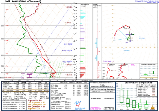
Key features:
- Boundary layer is well mixed (dry adiabatic temperature profile and constant water vapor mixing ratio)
- A cap (and a rather large one at that)
- An elevated mixed layer extended up to nearly 500 mb (nearly dry adiabatic temperature profile)
- Dry midlevels
- Southerlies at the surface
- Westerlies aloft
Of note, the hodograph has a lot of low-level shear with almost all of the 0-6 km shear contained within the lowest 1 km. The LCL is also somewhat low. These are both favorable for tornado formation. The big question is whether a storm will actually fire, as this sounding has considerable convective inhibition (CIN) from the large temperature inversion capping the boundary layer. This is a morning sounding though and so there is plenty of time for the temperature to evolve. The cap can be broken through pure solar heating, though requiring a temperature of 94 F to do so. Throughout the day the boundary layer will be mixing with the cap, which will reduce its strength. Moistening the boundary layer can also help decrease the CIN. Aside from the large cap in the morning, this is a setup favorable for supercells and severe weather.
And the result? As of 2218Z, here is a view of the Jackson, MS radar:
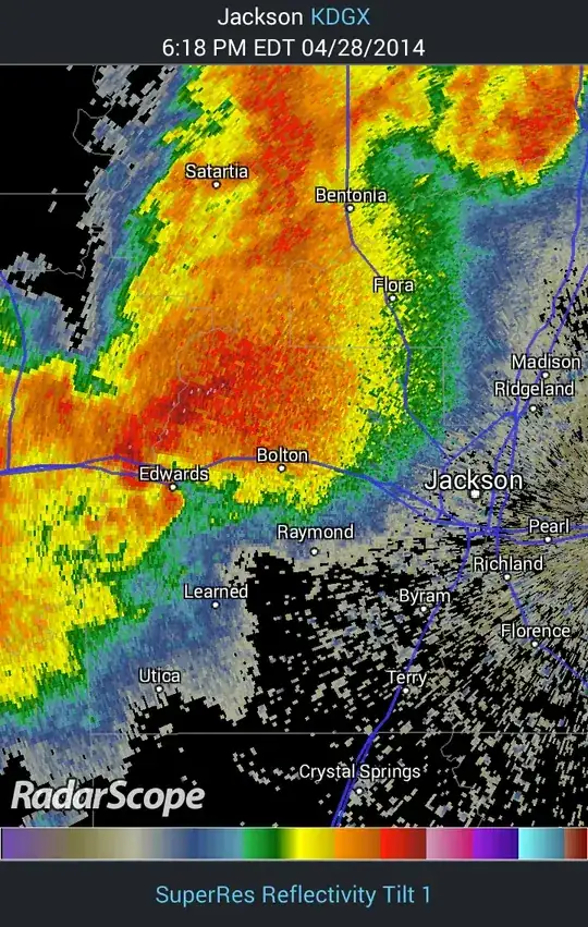
This is a supercell (well, a line of them and a bit messy looking) with a possible tornado due west of Jackson and moving to the east.
For a broader picture, lets also take a look at the 18Z NAM.
Surface moisture:

This shows a tongue of moisture being advected by the southerlies out of the gulf.
Surface temperature (F):
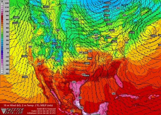
It is also warm.
Surface based CAPE:
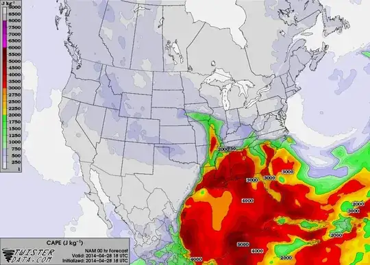
Put this together with midlevel lapse rates and we have lots of CAPE. But do we have adequate shear? Here is the 500 mb flow:
500 mb height and relative vorticity:
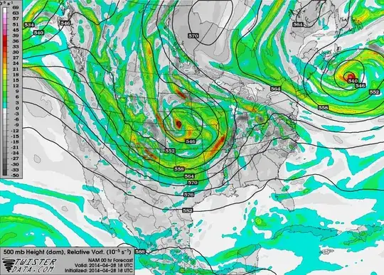
Flow somewhat westerly, but direction is not as important as the magnitude.
Surface to 500 mb shear:
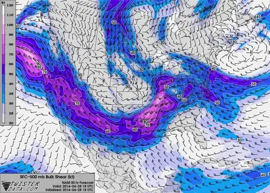
And as this shows, we have plenty of shear.
This is a classic setup for severe weather and the frequency that this setup occurs and the resulting weather is how tornado alley earned its name.