I heard that the FAA recently changed how they calculate the protected area for circling approaches, and it looked quite complicated because it changes based on altitude and speed, etc. Can you please explain how you know when to use the old -vs- new criteria, what distance you can safely use, and how to figure it out quickly when flying?
Asked
Active
Viewed 4,278 times
12
Qantas 94 Heavy
- 10,432
- 7
- 66
- 115
Lnafziger
- 58,886
- 39
- 242
- 423
-
1Do you have an example of an approach in which the new criteria have taken effect? – egid Jan 13 '14 at 01:58
-
1@egid No, I think that the first ones will be coming out in May. – Lnafziger Jan 13 '14 at 02:04
1 Answers
5
The protected area for circling approaches is based on distance from the runway(s), and the size of that area (and your approach MDA) depends upon your aircraft's VREF or 1.3×VSO — or, if higher, your actual IAS approach speed. Here's the graphic the FAA uses to demonstrate this, along with the old protected area radii:

New circling minumums
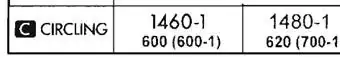
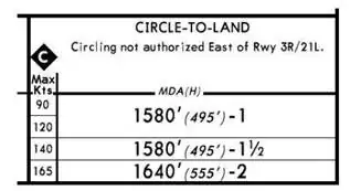
For approaches that use the new criteria, both Aeronav and Jeppesen charts show an inverted "C" in the circling minimums section of the approach plate. This signifies that the approach uses the new, altitude-dependent protected areas. Those areas are defined in the same way as before, but with different radii.
Aeronav (NACO) format:
Jeppesen format:
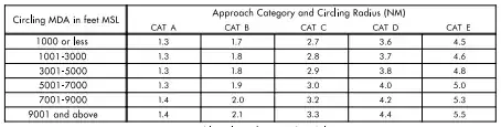
As far as figuring out how large your protected area is in flight, you'll have to use the inverted "C" as a cue to look up the table that will be included in the appendices of the approach plates:
The NBAA has a more detailed description of the changes, but this basically sums it up.
The update leaves us with what is honestly a less-than-desirable system. Looking up a table to brief your circling radius in flight (or even prior to your flight) is certainly a lot less useful than simply printing the protected area radius on the minimums section. It's worth noting that feature was proposed in 2009 (p. 4) when the change was being discussed.
egid
- 23,271
- 9
- 95
- 160